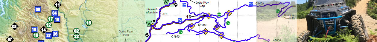
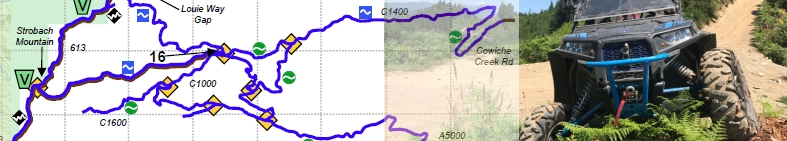

Along with every guide book purchase, either electronic or printed, you get a set of GPS files in the open source GPX format. You can import these files into your GPS device or navigation app, such as Backcountry Navigator. If your tablet or phone is running Android and has a GPS, there’s a good chance you can follow these instructions and use these files on your device. I tested these instructions on a friend’s Samsung Galaxy S5 smartphone as well as my tablet. As far as I know, BCN is not available on IOS.
You’ll also want a basemap to provide context for the GPS lines, and it should be one that can be made available offline because there is very limited cellular service where most of these trails go.
Once you have performed these tasks, you will be able to view good TOPO maps in BCN on your Android device, and show my GPS tracks on those maps, out on the trail without any access to cellular or WiFi service. If you bought the PDF version of the UTV Guide, you’ll be able to load that up and take it with you as well!
Note: Updates to BCN may change the exact wording or locations of the menus. As I become aware of changes, I will update this page.
Get Backcountry Navigator Pro
First, on your GPS-enabled Android device, go to the Play Store and purchase BackCountry Navigator Pro. I highly recommend the Pro version over the free version. It’s inexpensive, and you can do much more with it.
Get some Offline Basemaps
Once you have BCN installed, the first thing you’ll want is a set of base maps that you can carry with you offline, for when you are riding outside cellular/WiFi service areas.
-
- Open BCN and click Map Layers.
- Click “What’s This?” next to Prebuilt Map.
- Click “First, click to install a theme”. It takes you to OpenAndroMaps.
- Scroll down to the Elevate 4 section and click the button for BackCountry Navigator.
- Follow the prompt to install. If it wants you to choose Elements vs Elevate, I like Elements better, though they are VERY similar, and you can switch back and for at any time. Don’t get sidetracked with comparing them right now, you can easily do that later.
- Then go back into BCN and back to Map Layers, back to “What’s This”, and click the “Click to find a download” link. That opens another page on OpenAndroMaps.
- Select USA on the right, then start downloading states.
- Once you have the zip files downloaded, click each one to extract it. It will ask for a folder to extract to, but does not let you browse so just keep it default. It will make a folder for each map. You can later grab the .map files out of these subfolders and consolidate them, but I found that BCN got slow to browse the contents of the map folder when I had too many in there, so I created three folders: West, Central, and East, and divided the maps into those three folders.
- Then you can delete the zipfiles and the folders it created after you have moved the map files elsewhere.
Once you have them all extracted and organized, it’s just a matter of going to Map Layers, choosing Prebuilt Map, and selecting the state you want.
Import Some GPX Files
- First, you need to get the files into the tablet/smartphone. You can either do this by copying them to the SD card directly, or emailing them to yourself, or using something like Google Drive or Dropbox to get them there. You want files with the .gpx extension.
- Then open BCN. Tap “Trip Data” and then “Create a new (empty) trip database. I suggest creating one database for each GPX file. It’s more time spent setting it up, but it will load faster when you go to an area and want to open the tracks for that area. You could skip pre-making these, and just make them one at a time while you import the files. Either way works.
- Then tap Trip Data, and “Import Tracks or Waypoints”.
- Browse to where you put the GPX file and tap on it.
- At this point you will be prompted to make a new trip database or put it in an existing one. If you pre-made them all earlier, tape “Existing Trip Database” and select it from the drop-down list on the right. If you didn’t pre-make them, choose “New Trip Database” and give it a name on the right.
- Having created a Trip Database, tap the START IMPORT button. When it has finished, you will be sent back to the main map page.
- Then you can tap “Trip Data” and “Choose Another Trip Database”. Select one of the ones you made, and tap “Choose This Trip”.
Happy GPSing!