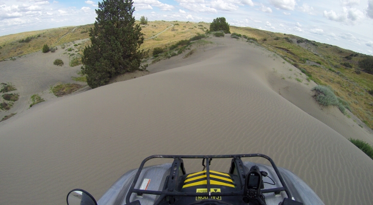
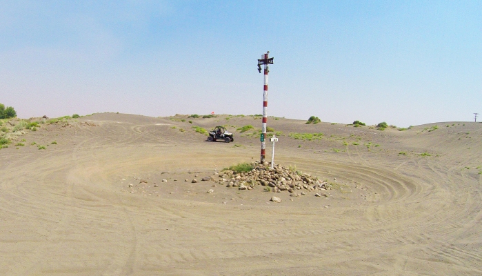
Manastash Ridge

Manastash Ridge is a great place to spend several days camping and riding. There are two campgrounds within a mile of each other, with many spots large enough for groups with multiple trailers. No reservations, arrive early to make sure you get the spot you want. Both campgrounds offer direct trail access. There is a kiddie loop in Manastash Camp, built for small children on bikes and ATVs, 100cc max. There are multiple public restrooms on site.

Most of the trails in this area are rocky, rooty, bumpy, off-camber, rutted out, and steep. In the winter, there are deep mud puddles that you will slide sideways into. This is a challenging area, not good for beginners.

Some of the trails take several hours to complete – and you have to travel them both directions due to the service roads not being open to ORVs even if you’re “street legal” (WATV metal tag with On Road tabs) at this time.

Get details including directions, staging areas, maps, and difficulty levels in the UTV Guide to WA State.

LT Murray Wildlife Area

This area consists of rolling hills, criss-crossed with roads that can be very rocky, with a few smoother roads mixed in there. You won’t find this to be a relaxing ride. There are a couple of good view points, but not many. There are a few shady areas, but a large portion of the roads in this area will be in direct sunlight, so be prepared for that.

Most of the roads are easy, except for the bumpiness. There are a few places where some ruts have formed, and a couple of not very steep hills, but most of the area is suitable for a less skilled rider.

You can ride on any road that has a white marker with a green dot on it.

Get details including directions, staging areas, maps, and difficulty levels in the UTV Guide to WA State.

LT Murray – Elk Heights Area

Elk Heights is a separated section of the LT Murray network of Green Dot roads surrounded on all sides by private property. It is very important that we stay on the legal marked Green Dot roads, not only to keep the government from closing them, but also to avoid issues with the local landowners.

These Green Dot roads are pretty typical for Green Dots – some areas are bumpy, some are smooth, and there are some deep ruts. Most of them have only mild elevation changes.
The area is full of nice looking forest, great smells, and a relaxed riding area that is good for the family.

Get details including directions, staging areas, maps, and difficulty levels in the UTV Guide to WA State.

Liberty

The Liberty area hosts a series of 4×4 trails in steep mountain terrain. When it is dry, the dirt can be loose and slippery in places. When wet, the mud will make it treacherous in most areas. There are lots of off-camber situations and steep hill climbs, often combined for extra fun.

Seasonal closure in effect from snowfall until it is announced open, which usually happens by Memorial Weekend. The “Cle Elum Trails Off-Road Team” Facebook group is a good place to check for updates.

This is a challenging area in the best conditions, much worse in winter. If you want a serious challenge, this is the place to go. Much of Liberty is not for beginners. Liberty is probably the 2nd hardest ORV area in WA.

Get details including directions, staging areas, maps, and difficulty levels in the UTV Guide to WA State.

Juniper Sand Dunes

I would be more inclined to call this area “Juniper Sand Trails” than Dunes.
The majority of the area is covered in scrub brush. Pick a direction you want to go, and there are sand trails through the brush headed that direction.
There are a few open dune areas. Taller dunes can be found further out. There are hundreds of little sandy hill climbs. All of the “mainline” sand trails that are used to get around are all whooped out. A power line runs across the area, and a petroleum pipeline runs the length of the area. Using those markers, it is easy to find your way back to the parking area if you get lost.

Get details including directions, staging areas, maps, and difficulty levels in the UTV Guide to WA State.

Cat Creek area of Gifford Pinchot NF

The Cat Creek area of Gifford Pinchot National Forest is currently the only area where roads are open to all vehicles. Even with your “street legal kit” and green restricted plate with ON-ROAD tabs, you are still not legal anywhere other than the roads marked for All Vehicles on the MVUM at this time. Those roads are what is covered in this book.

Most of these roads are fairly smooth. As you get further North and East away from the main NF-21 road and campgrounds, it gets rougher, but it never becomes challenging. Some of the roads are little-used by wider vehicles and are becoming somewhat overgrown.

If you stay on the designated routes, the entire area mileage is about 36 miles. But you will likely do some backtracking, so you could easily put on 75 miles in maybe 4-5 hours of riding.

Get details including directions, staging areas, maps, and difficulty levels in the UTV Guide to WA State.

Fortune Creek

Fortune Creek is home to a series of 4×4 trails, consisting of 4W301-304, and a separate trail, 4W305. 4W301-304 make their way up the mountain, passing Gallagher Head Lake before terminating with some excellent scenic view points. This area makes a great destination for a day trip.

The entire system of trails is about 28 miles. You’ll do some parts both directions, though, so figure about 40 miles of riding if you do everything. The entire system can be done, both directions, in about 6 hours.

Get details including directions, staging areas, maps, and difficulty levels in the UTV Guide to WA State.


Evans Creek ORV

Evans Creek ORV Park is one of the most challenging ORV areas in the state. There are easy sections, but if you limit yourself to those, you won’t do much riding here. It is primarily a 4×4 trail system, popular with jeeps and pickups. Expect deep ruts and exposed boulders and tree roots, off-camber trails, and significant elevation changes.

There is an excellent view of Mt. Rainier just under 1 mile up the first trail. There are some rock climbing challenges as well.

Get details including directions, staging areas, maps, and difficulty levels in the UTV Guide to WA State.

Elbe Hills ORV

Elbe Hills ORV Area is well known to be very muddy, with deep ruts created by the heavy jeeps and trucks that frequent the area. This can be very challenging for UTVs and ATVs, but it is still passable. Most of the trails are not far off of the main service roads through the area, so you can turn back and bypass something if it’s too rough. There are only about 8 miles of official trail, but there are so many side tracks it will keep you busy most of the day, especially if you encounter 4×4 traffic.

Most of the trails are pretty much the same, but Swamp and Gotcha trails have some logs set up as obstacles, which can be pretty fun.

Get details including directions, staging areas, maps, and difficulty levels in the UTV Guide to WA State.

Douglas Creek Recreation Area

22,000 acres of dry sage steppes, cut by a lush riparian oasis along Douglas Creek. Songbirds and raptors abound in the cottonwoods and cliffs of this protected canyon, while beaver and trout thrive in the pools and cascades of the stream. 4 miles of access roads & trails open to OHVs. Hunting, dispersed camping, hiking, wildlife watching, fishing and swimming are also permitted in this area.

The waterfall and swimming hole is a good place to hang out on a hot summer day. Also get up on the hilltop for a great view of the surrounding area.

You can ride the whole area in a couple hours if you stay on the gas pedal, but that’s not really what this area is about. Take it easy, stop and smell the flowers and the wildlife poop, crack open a cool one, chill in the creek, or just sit and listen for a while. You’re miles from anything.

Get details including directions, staging areas, maps, and difficulty levels in the UTV Guide to WA State.

Your Virtual Guide to Off-Road Destinations